

Know What's Beneath Your Next Foundation
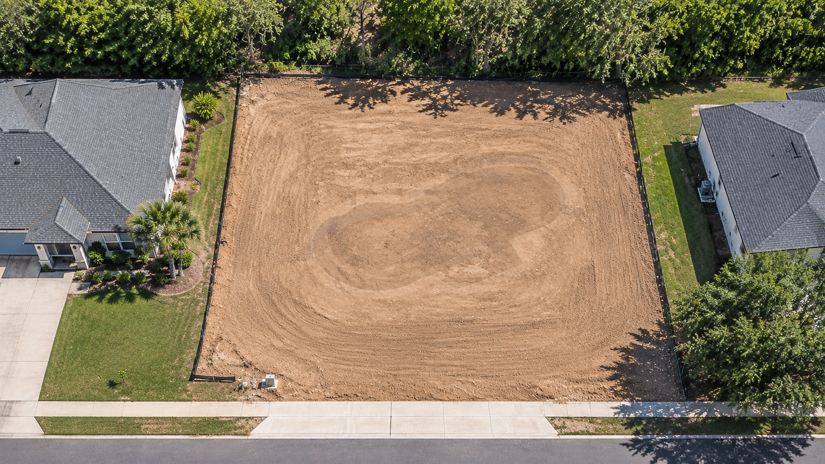
A lot's history can be just as important as its current appearance. Former ponds and swimming pools may be hidden beneath a level building pad, leaving undocumented fill within the footprint of a new foundation. Without proper preparation, fill placement, and compaction testing, these areas can settle unevenly and cause costly foundation damage.
Why buried pools and ponds matter
A pool or pond is a hole in the ground. When it is filled in, what matters is how the fill went in. Soil dumped in loose, or placed in thick layers without testing, can look perfectly firm on the surface and still compress over time under the weight of a house. Because the filled area is usually next to undisturbed native soil, the two settle by different amounts. That uneven movement (differential settlement) is what cracks slabs, stem walls, and drywall, and causes sticking doors and windows.
Filled pools carry an added concern. A pool shell left partly in place can act like a bowl, trapping water in the soil above it. Building departments that regulate pool demolition commonly point to both problems: saturated soil, and uncompacted fill that cannot support a future structure.
Filled ponds bring their own questions: what was removed from the bottom before filling (soft, organic material is generally unsuitable for supporting a foundation), what was used to fill, and whether anyone tested it.
What the code and local jurisdictions expect
The International Building Code, on which the Florida Building Code is based, calls for a geotechnical investigation when shallow foundations will bear on compacted fill more than 12 inches deep. That investigation must specify site preparation, acceptable fill material, how maximum density will be determined, lift thickness, and how field density will be tested. Fill placed under a building is expected to follow the approved geotechnical report and be verified by testing and inspection.
Local requirements for pool demolition go further in many places. Some jurisdictions require geotechnical-engineer supervision and a compaction report before final inspection if anything will be built over the old pool, and some prohibit building over a pool that was simply abandoned in place. Required compaction levels are set by the geotechnical engineer for the specific project.
What it looks like on the ground
The two exhibits below show how easily these features disappear.
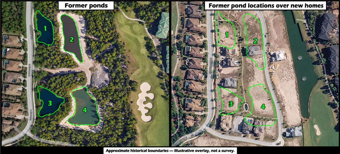
Figure 1. Left: four former ponds beside a golf course. Right: the same area after development, with the approximate pond outlines overlaid on new building pads and homes. Approximate historical boundaries; illustrative overlay, not a survey.
In Figure 1, the ponds are clearly visible in older imagery. Today, the pads look level and ordinary, and nothing at the surface shows what is underneath.
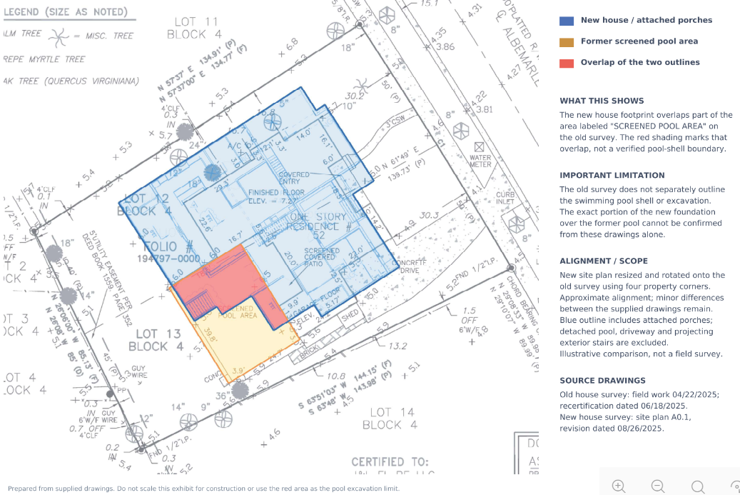
Figure 2. A new house footprint (blue) overlaid on an older survey that labeled a "screened pool area" (orange). The red area shows where the two outlines overlap. The old survey does not outline the pool shell or its excavation, so the exact portion of the new foundation over the former pool cannot be confirmed from these drawings alone. Approximate alignment; illustrative comparison, not a field survey and not for construction use.
Figure 2 shows a second way to find the problem: comparing an old survey to the new site plan. Here, part of the new footprint sits over the former pool area. Note that the older survey only labels the pool area; it does not show how deep the pool was or how it was closed. Only investigation can answer that.
How to spot a hidden pool or pond
- Review historical imagery. Google Earth's historical imagery feature (use the satellite view and turn on Historical imagery) lets you step back through older aerial and satellite images. Historic Aerials is free to browse and offers imagery and old topographic maps for many US locations. Coverage and dates vary by location, so a clean result does not prove a lot was never disturbed.
- Check old surveys and plats. Look for labels such as pool, screened pool area, pond, or lake, and for old structures that no longer exist.
- Search permit records. Ask the building department for demolition, pool, grading, and fill permits on the parcel.
- Walk the site. Look for slight depressions, changes in vegetation or soil color, patches of imported fill, or a pad that is unusually level compared with surroundings.
- Ask. Sellers, previous builders, and neighbors often know what used to be there.
If you find one
- Involve a qualified geotechnical engineer before placing fill or beginning foundation work.
- Obtain site-specific recommendations for removing unsuitable materials, placing and compacting fill, and testing to document that the completed work meets those recommendations.
- Have the testing performed while the fill is being placed. Compaction cannot be verified after the fact by looking at the surface.
- Keep the report, test results, and engineer's certification with the project file, and make sure the foundation plans reflect them.
If the area has already been filled without testing
Additional geotechnical evaluation will be needed to assess whether the fill is suitable for foundation support. Depending on what is found, an engineer may recommend removing and replacing the fill, improving it, or supporting the foundation on deeper elements that bypass it. Each option is far less costly before the foundation is poured than after cracks appear.
Contact Maverick early and submit the available reports and testing documentation for review. Undocumented fill may affect eligibility for structural warranty coverage.
The bottom line
Our goal is to help you prevent avoidable problems, protect your investment, and deliver homes your customers can enjoy with confidence. A few hours with old imagery and a call to a geotechnical engineer cost far less than repairing a settled foundation.
This article is intended for general informational purposes only and should not be considered engineering, legal, or construction advice. Site conditions and local building requirements vary. Builders should consult a qualified geotechnical engineer and their local building department for project-specific recommendations and requirements.